
It’s actually very easy to get data from a shapefile onto OpenStreetMap using OpenLayers and the GMapCreator. The example below shows the social cohesion data from Mark Easton’s BBC blog
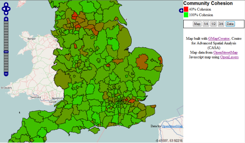
The working OpenLayers/OpenStreetMap map can be viewed at the following link: http://www.maptube.org/maps/BBC/MarkEaston/communitycohesiondata.html
This page was generated using the GMapCreator and a custom template that I created for OpenLayers. The resulting map page could be completely Google free if required, but this one includes the Google map, satellite, hybrid and terrain layers as options, along with the OpenStreetMap Mapnik and Osmarender base layers.
The prototype GMapCreator template can be downloaded from the following link (right click on it and use ‘save as’ to save the file):
http://www.casa.ucl.ac.uk/richard/GoogleMapCreator/GMC_OSM_template.html
The file is loaded into the GMapCreator from the ‘Edit’ menu and the ‘Use Custom HTML Template’ option. All suqsequent maps will then use this template until the option is turned off.
Richard Milton, CASA, UCL