From Tile Pyramids to Population Pyramids

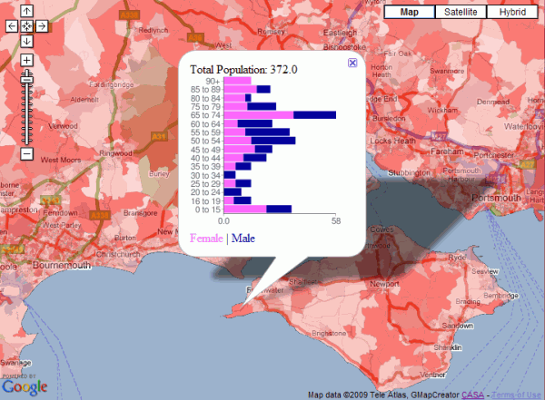
It’s actually a stacked bar chart rather than a traditional population pyramid, but the image below shows male/female population by age for all the output areas in England. The red thematic overlay is total population for every OA, which can be clicked to get the age group breakdown shown in the popup window.

Clickable Age Map
Clickable Age Map

This map is a variation on the original clickable OAC map and was built using a new version of the GMapCreator which contains the clickable technology. Traditionally, maps like this have been built using a server and database to translate the click on the client into a geographic area using point in polygon and then sending the query data back to the client. This method doesn’t scale when you have limited server resources and are looking to handle high numbers of hits, for example with the Mood Maps that we’ve been doing recently. An alternative solution is to build feature coded tiles and let the client handle most of the work displaying the data. Using this system, there is a second set of tiles, one of which the client downloads when the user clicks on a point. This allows the client to work out which feature has been clicked and request the data for that area as an xml file.

The hard part is designing a system which can allow people to design the popup window without having to resort to programming. In the example above, the graph was created using Google Charts via the GMapCreator’s user interface. All that was needed was to choose the data fields from a list and to select the chart type. The URI string to create the chart comes from an xslt transform applied to the xml data. This transform is automatically created by the GMapCreator interface, which also allows the rest of the popup window to be designed using a simple html editor.

Downloadable Preview – GENeSIS Exhibition Space

The following exhibition space is a proof of concept, looking at the ability to share and display city datasets and simulations within an interactive game engine. Available for download on both the PC and Mac (intel) platforms the space is the result of a few days work with the Unity Engine, it is intended to be viewed in the spirit of development rather than a completed product.

The room includes our first ‘crowd and delegate’ models direct from 3D Max, created as basic wander and avoid simulations they provide the building blocks of emergent behaviour within the cityscape.

City wide data sets can to be honest be very ‘dry’, the whole point of digital urban is to look at new ways to outreach, visualise and ultimately communicate urban data. The ability to include 3D models via ESRI ArcScene is a notable step forward, pictured below is the retail and office space in London measured on a 500m grid. We note some polygon issues here but these are known and we think we have a way to fix them – its to do with the way ArcScene exports, the model forms the centre of the exhibition space:

The room features various architectural models, including the Swiss Re building and the GLA in London, it also features a number of our latest output movies, the London LiDAR and Second Life Agents are of particular note.

The model is, as we mentioned, proof of concept, the next step is the addition of themed rooms and a more organised structure. We think the concept of virtual exhibition spaces is a strong one, so as ever any comments are most welcome…

Download the model for Windows XP/Visa (221 Mb zip file)

Unzip the file, open the folders and run the .exe file.

Download the model for Mac (222 Mb zip file)

Extract and simply run the .dmg file.

Use the mouse to look around, W/S move forwards/backwards, Space to jump.

GENeSIS Exhibition Space

We have spent the last few days giving the game engine Unity a spin. The pro version has various additions to the lower cost indie edition, most notably for our use the ability to import movies as textures and use dynamic shadows. Our movie below provides an update on progress:

Unity: Creating a City Exhibition Space – Update 2 from digitalurban on Vimeo.

The aim is to create an exhibition space exploring simulation and the city… more to follow.

Visualising City Datasets

The movie below is a visualisation of office and retail space in London. Using data kindly supplied by the Economics Unit at the Greater London Authority, Duncan Smith a PhD student here at CASA has calculated the amount of retail and office in London per 500 metre grid square:

Duncan carried out the analysis in ESRI’s ArcScene as part of his PhD. Intriguingly it is possible to export from ArcScene into Autodesk’s 3D Studio Max allowing a much higher level of visual fidelity. Of course once it is in max you can then export to a number of other platforms, such as Unity as our previous post on digital urban explained using the same data.

Here at CASA we have just completed the initial phase of our London database, as such we will be exploring more ways to visualise city based datasets in forthcoming posts.

Tiled Maps without the Internet

This is one of those things that’s obvious once you know it, but I’ve often found myself developing code for tiled maps, but without a connection to the Internet. Often, I just want a quick check to see if the tiles are rendered correctly, so I don’t need the background map.

The obvious solution is to create an OpenLayers page with your custom tiles as the base layer. The javascript that makes OpenLayers work can be served locally, unlike the Google API, so by only having one layer of locally served tiles, you don’t need an Internet connection.

The html pattern follows the OpenLayers ‘howto’ guide and uses a custom TMS layer as follows:

var googlecustom=new OpenLayers.Layer.TMS(“Test”,http://www.casa.ucl.ac.uk/googlemaps/,{ ‘type’: ‘png’, ‘isBaseLayer’: true, ‘getURL’: TMSCustomGetTileURL });

The ‘TMSCustomGetTileURL’ returns the tile url based on the x, y and z value in whatever format you are storing tiles in. For this project, it was the keyhole string format.

OpenLayers map showing the BBC Look North Recession data using dynamic tile creation
OpenLayers map showing data from the BBC Look North Recession mood map using dynamic tile creation

The image above was taken from a prototype system using C# and SQL Server 2008 to generate tiles dynamically from data stored in a CSV file at a URL.